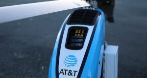
A month after experiencing catastrophic devastation due to Hurricane Maria, Puerto Rico is still struggling to recover. With 48 percent of cell sites still out of service, residents and officials struggle to communicate across the island. To help get residents connected again AT&T deployed its Flying Cell on Wings (COW) for the first time.
Esri has deployed the CrowdRescue Puerto Rico Infrastructure Map, which displays crowdsourced reports about damage from Hurricane Maria affecting the U.S. territory. The map enables a visualization of closed roads, collapsed bridges, flooding, mudslides, areas where communication is unavailable, areas that don’t have power, areas without drinking water, and areas with downed power lines.
Stay Connected

